
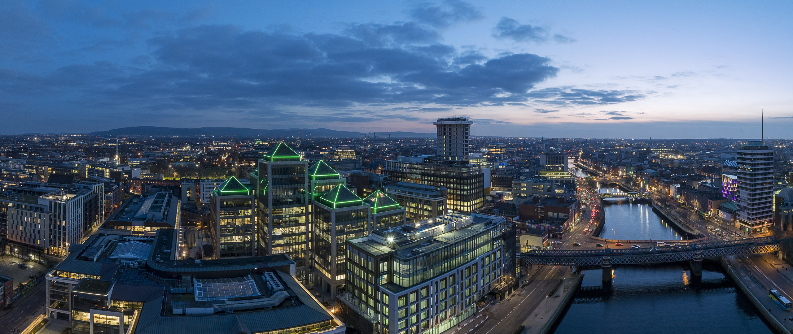
Are you in search of captivating aerial imagery to showcase your residential or commercial real estate? Look no further! At abdone studio, we specialize in providing top-notch aerial photography and drone videography services tailored specifically to the real estate industry.
Whether you’re aiming to capture the essence of a residential property or highlight the unique features of a commercial building, our licensed drone photographer and aerial videographer is equipped with state-of-the-art drones and advanced photography equipment to deliver stunning aerial views from above.
From breathtaking drone photography and aerial video that captures the essence of your residential property to immersive FPV flythru videos that showcase the commercial potential of your building, we have the experience and expertise to bring your vision to life. Our skilled cinematographer and FPV videographer in collaboration with professional video/photo editor ensure a seamless and cinematic experience for your audience, emphasizing the unique selling points of your property.
But our services extend beyond just aerial imagery. At abdone studio we take pride in our ability to turn your real estate vision into reality, no matter how complex. Whether it’s a residential neighbourhood or a commercial complex.
Before initiating any aerial photography project, we conduct a thorough assessment of both site and weather conditions to pinpoint the ideal moment to commence the photoshoot. This meticulous evaluation ensures that we select the most opportune time to capture stunning aerial imagery while accounting for various factors such as visibility, lighting conditions, and environmental elements. By prioritizing this preparatory phase, we guarantee optimal outcomes for our clients and ensure the success of each project.
We carry a full umbrella insurance in Public Liability Cover as well as insurance for damages by operating our drones. Our pilot is fully qualified, licensed by the Irish Aviation Authority (IAA) and European Union Aviation Safety Agency (EASA)

We offer flexible solutions to adapt to the needs of any project and guarantee professional footage that enhances the appeal of your property, no matter its location. Let us help you elevate your real estate marketing efforts to new heights!
24 Hour Cancellation Policy
Because your time is important we promise to be on agreed location on time and finished on time. In return we ask that you respect our time and provide us with a minimum of 24 hours if you need to cancel or reschedule your booking. If you cancel last minute, are late to the property, or a no-show, we are kindly asking to avoid this kind of situation. If we do not hear from you and our real estate photographer gets there and finds out that we need to cancel – we will charge the full rate. Exceptions will be made for extraordinary circumstances. We understand things come up, but please consider our schedule.
Payment
An invoice will be emailed before images are available for download. Unfortunately we cannot accept cash or check. Payments can be made online with most major credit cards.
1. Plan
We leverage extensive experience in meticulously planning shoots and flight route mapping. Additionally, we proactively secure all necessary permissions from both landowners and regulatory bodies at this juncture.
2. Shoot
Now commences the practical phase of our operation. With meticulous planning completed, we transition into the execution of capturing the desired shots.
3. Edit
After the stills and video files have been securely backed up, they are handed over to our proficient in-house editors to undertake their expertise.
4. Delivery
Depending on the client’s requirements, we offer the option to transmit files digitally through our secure content asset management website or deliver them via hard drives. Our objective is to expedite the delivery of final content promptly and efficiently.
How We Work
At every step of the way, we prioritize collaboration with our clients to ensure the highest quality output. From meticulously planning the project to obtaining necessary permissions and reviewing the final edit, we are dedicated to working closely with you throughout the entire process. Your satisfaction and vision are at the heart of everything we do.
Should the project move forward…
We kindly request that you furnish us with a formal letter confirming your booking for the aerial flight, along with the precise Google Maps or GPS coordinates pinpointing the site. Following this, we will meticulously craft a comprehensive flight plan and initiate the licensing process with IAA, typically yielding approval within a span of three to four days. Regrettably, we cannot assure the commencement of the flight until our licensing application has been successfully processed. Your understanding and cooperation in this matter are greatly appreciated as we strive to ensure the seamless execution of the project.
If you wish to have your project evaluated for its compatibility with aerial photography/video, please don’t hesitate to contact us.
Aerial Drone Photography and Video Packages for Dublin City and & surrounding areas (for residential and commercial properties)
Given the distinctive nature of each project and the multitude of variable factors involved, we find it most effective to provide personalized quotes on a per-project basis. However, we understand that many of our clients seek preliminary cost estimates to guide their decision-making process. Therefore, as a convenient reference points:
Aerial Drone Photography
€295
€295
- Per session (Up to 10 aerial photos) All photos delivered in high resolution.
- Up to 1 hour on location.
- Delivery: 48 hours delivery (compressed zipped folder to download)
- High resolution photos, format: JPG: 5272 pixels x 3948 pixels, raw files available on request.
- Full post processing with professional colour correction included in the price.
- * IAA regulations regarding airspace
Aerial Drone Photography and Video
€535
€535
- Per session (Up to 15 aerial photos plus aerial video). Available video format to choose from: 5K, 4K, Full HD. All photos delivered in high resolution.
- Up to 2 hours on location.
- Delivery: 48-72 hours delivery (compressed zipped folder to download)
- High resolution photos, format: JPG: 5272 pixels x 3948 pixels Available Video formats: 5.1K, 4K, Full HD
- Full post processing with professional colour correction/grading, video editing included in the price.
- Raw files available on request.
- * IAA regulations regarding airspace
Aerial Drone Photography and Video
€720
€720
- Per session (Up to 30 aerial photos plus aerial video). Available video format to choose from: 5K, 4K, Full HD. All photos delivered in high resolution.
- Up to 4 hours on location.
- Delivery: 48-72 hours delivery (compressed zipped folder to download)
- High resolution photos, format: JPG: 5272 pixels x 3948 pixels Available Video formats: 5.1K, 4K, Full HD
- Full post processing with professional colour correction/grading, video editing included in the price.
- Raw files available on request.
- * IAA regulations regarding airspace
Aerial Drone Photography and Video
€1,250
€1,250
- Per session (unlimited aerial photos plus aerial video). Available video format to choose from: 5K, 4K, Full HD. All photos delivered in high resolution.
- Full day (8 hours)
- Delivery: 72 hours delivery (compressed zipped folder to download)
- High resolution photos, format: JPG: 5272 pixels x 3948 pixels Available Video formats: 5.1K, 4K, Full HD
- Full post processing with professional colour correction/grading, video editing included in the price.
- Raw files available on request.
- * IAA regulations regarding airspace
For homes/apartments below 3229 square feet / 300 sq. meters please contact us for a quote.
* IAA regulations regarding airspace – There are numerous locations where drone pilots can operate their drones outside of urban areas while adhering to safety and IAA regulations regarding airspace. Typically, this pertains to Class G airspace, which is generally unrestricted, particularly up to 400ft/120m.
However, in urban settings such as towns, villages, and cities, navigating airspace regulations becomes more intricate. Drone pilots are prohibited from flying over gatherings of people, and depending on the drone’s category, flight over uninvolved individuals is also restricted.
Take Dublin, for instance. Given the presence of Dublin Airport, hospitals, prisons, sensitive installations, and military bases, nearly all of Dublin County falls under controlled airspace or Class C designation. Additionally, several Prohibited Airspaces exist within the Dublin Control Zone, including the Phoenix Park. Nonetheless, drone operators can still fly in most open areas, maintaining altitudes of up to 100ft/30m above ground level and 90m in certain Dublin zones.
Beyond these limits, securing Air Traffic Control clearance is imperative due to the potential for various forms of manned aviation unexpectedly entering the airspace. Examples include the Coast Guard and Garda Helicopter, which frequently operate in the vicinity. Ensuring compliance with these regulations is crucial for the safety of both drone operators and manned aircraft.
Got other questions? Contact us at your convenience below by email or alternatively call us on: (+ 353) 087 197 39 66
Terms of Service
[1] Pricing: Prices are for Dublin City and surrounding areas up to 20 km. Travel charges may apply outside of this area. All prices are subject to VAT 23%.
[2] Payment: Payment is due before images are available for download. Unfortunately we cannot accept cash.
[3] Bad Weather: In the case of rainy / inclement weather, we can shoot your property’s interior, but you may want to reschedule your shoot. It’s no charge to reschedule a shoot due to inclement weather, but if we have to return at a later time for additional shots, then additional charges will apply.
[4] Cancellation: If you need to cancel your shoot, please give us a couple days advance notice. If you cancel last minute, are late to the property, or a no-show, we are kindly asking to avoid this kind of situation. We understand things come up, but please consider our schedule.
[5] Copyrights: You can use the images we provide for just about anything in relation to your business. If you need the images to be exclusive where we couldn’t also use them to promote our business, then an added fee may apply. You are allowed to use the images for your own website / property listing or advertising your business.
Full Terms and Conditions are available here